


Offline Waypoints Free
คำอธิบายของOffline Waypoints Free
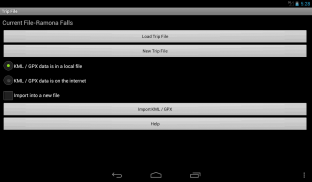
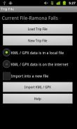
Offline Waypoints was designed from the ground up as an offline maps and way point solution. Plan your trip using the App, Google My Places, Google Earth, or any software that allows for KML or GPX exports.
After you import or create your waypoints you can easily download all of the map information you need for your journey with just a couple of buttons when you have an internet connection. This will save you money (sometimes hundreds of dollars) by avoiding roaming fees when you leave your service area. It will save you from getting lost when you are going somewhere without service at all.
There is no need to spend time selecting areas for download. There is no storage space wasted by downloading unneeded map data.
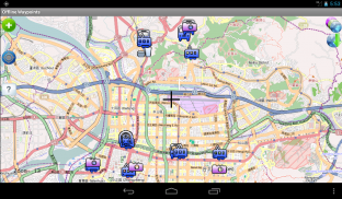
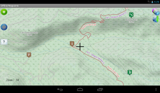
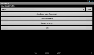
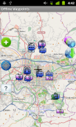
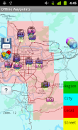
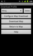
Offline Waypoints downloads the map area around the waypoints in your trip. Select how far away from each waypoint to download map data by your activity type (hiking, driving, city walking, etc) or using your own custom settings in an easy to use screen.
Here is a list of the features found in this app:
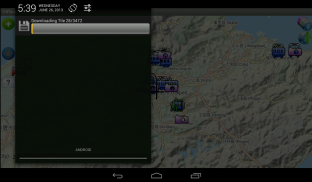
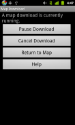
- Downloads map information as a background process so you can do other things with your device.
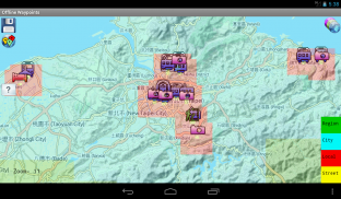
- Get a preview of where information will be downloaded before starting the tile download process.
- All way point information is stored offline on your device's external storage space. There is no need to be online once the map data is loaded.
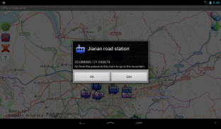
- Add new way points using the coordinates on the screen cursor, or your current GPS location.
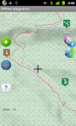
- Way points are easily edited with on screen controls.
- Set how long for the app to retain GPS lock when the App is not in use for areas where it is hard to get a lock.
- Regain storage space by selecting previously downloaded map areas to delete.
Note on Google Maps:
Due to it's license for use, Google Maps tiles can not be stored locally. This app is meant as an offline map solution. However, if there is enough support I can add a Google Map Layer that is online use only.
</div> <div jsname="WJz9Hc" style="display:none">Waypoints เพศได้รับการออกแบบจากพื้นดินขึ้นเป็นแผนที่แบบออฟไลน์และการแก้ไขปัญหาจุดทาง วางแผนการเดินทางของคุณโดยใช้ App, Google สถานที่ของฉัน, Google Earth หรือซอฟแวร์ที่ช่วยให้การส่งออกหรือ KML GPX ใด ๆ
หลังจากที่คุณนำเข้าหรือสร้างจุดคุณสามารถดาวน์โหลดข้อมูลทั้งหมดของแผนที่ที่คุณต้องการสำหรับการเดินทางของคุณมีเพียงคู่ของปุ่มเมื่อคุณมีการเชื่อมต่ออินเทอร์เน็ต นี้จะช่วยให้คุณประหยัดเงิน (ร้อยบางครั้งของดอลลาร์) โดยหลีกเลี่ยงค่าธรรมเนียมการใช้บริการโรมมิ่งเมื่อคุณออกจากพื้นที่ให้บริการของคุณ มันจะช่วยให้คุณประหยัดจากการสูญหายเมื่อคุณจะอยู่ที่ไหนสักแห่งโดยไม่ต้องให้บริการทั้งหมด
ไม่จำเป็นต้องใช้เวลาในการเลือกพื้นที่สำหรับการดาวน์โหลดไม่มี มีพื้นที่จัดเก็บไม่ได้ถูกทำลายโดยการดาวน์โหลดข้อมูลแผนที่ที่ไม่จำเป็นคือ
Waypoints ไลน์ดาวน์โหลดแผนที่ของพื้นที่ที่อยู่รอบ ๆ จุดในการเดินทางของคุณ เลือกวิธีห่างไกลจาก waypoint แต่ละเพื่อดาวน์โหลดข้อมูลแผนที่ตามประเภทของกิจกรรม (เดินป่า, ขับรถ, เดินเมือง ฯลฯ ) หรือของคุณใช้การตั้งค่าของคุณเองง่ายในการใช้หน้าจอ
นี่คือรายการของคุณสมบัติที่พบใน app นี้คือ:
- ข้อมูลแผนที่ที่ดาวน์โหลดเป็นกระบวนการพื้นหลังเพื่อให้คุณสามารถทำสิ่งอื่น ๆ กับอุปกรณ์ของคุณ
- รับตัวอย่างของการที่ข้อมูลจะถูกดาวน์โหลดก่อนที่จะเริ่มขั้นตอนการดาวน์โหลดกระเบื้อง
- ข้อมูลทั้งหมดที่ชี้ทางถูกเก็บไว้ออฟไลน์บนพื้นที่จัดเก็บของอุปกรณ์ภายนอก ไม่จำเป็นต้องมีที่จะออนไลน์ทันทีที่ข้อมูลแผนที่มีการโหลดไม่เป็น
- เพิ่มจุดวิธีการใหม่โดยใช้พิกัดของเคอร์เซอร์บนหน้าจอหรือตำแหน่ง GPS ของคุณในปัจจุบัน
- จุดที่มีทางแก้ไขได้อย่างง่ายดายด้วยการควบคุมหน้าจอ
- ตั้งนานแค่ไหนสำหรับ app ที่จะรักษา GPS App ล็อคเมื่อไม่ได้ใช้งานสำหรับพื้นที่ที่มันยากที่จะได้ล็อค
- คืนพื้นที่จัดเก็บโดยการเลือกพื้นที่บนแผนที่ดาวน์โหลดมาก่อนหน้าเพื่อลบ
หมายเหตุบน Google Maps:
เนื่องจากใบอนุญาตมันสำหรับการใช้งานกระเบื้อง Google Maps ไม่สามารถเก็บไว้ในเครื่อง app นี้มีความหมายเป็นวิธีแก้ปัญหาแผนที่แบบออฟไลน์ แต่ถ้ามีเพียงพอสนับสนุนฉันสามารถเพิ่มเลเยอร์ที่ Google แผนที่ออนไลน์ที่ใช้เฉพาะ</div> <div class="show-more-end">
Offline Waypoints Free--เวอร์ชั่น1.7.2
(29-06-2015)Offline Waypoints Free - ข้อมูล APK
เวอร์ชั่น APK: 1.7.2แพ็คเกจ: com.rjs3software.OfflineWaypoints.Freeเวอร์ชั่นล่าสุดของOffline Waypoints Free
เวอร์ชั่นอื่น


 3.78
3.78แอปในประเภทเดียวกัน


